- Huangshan UNESCO Global Geopark
- Naturtejo UNESCO Global Geopark, Portugal
- Central Catalonia UNESCO Global Geopark, Spain
- Jiuhuashan UNESCO Global Geopark
- Yandangshan UNESCO Global Geopark
- Sanqingshan UNESCO Global Geopark
- Longhushan UNESCO Global Geopark
- Terra Vita UNESCO Global Geopark, Germany
- Huanggang Dabieshan UNESCO Global Geopark
- Fangshan UNESCO Global Geopark
- English Riviera UNESCO Global Geopark
- Guangwushan-Nuoshuihe UNESCO Global Geopark
- Zhijingdong Cave UNESCO Global Geopark
- Dali-Cangshan UNESCO Global Geopark
- Xiangxi UNESCO Global Geopark
- Yuntaishan UNESCO Global Geopark
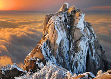
Huangshan UNESCO
Global Geopark located in the south of Anhui Province, at a latitude of 30 degrees north, features a granite peak forest landscape. It covers an area of 160.6
square kilometers, where the granite outcrop area accounts for 70% of the park.
The highest peak is called the Lotus Flower, 1,864 meters above sea level.
The granite landforms in Huangshan Geopark record tectonic movement,
magmation, weathering, action of gravity, denudation, and transportation,
making it the best site for the study of the formation mechanisms of granite landscapes.
Huangshan Geopark vegetation coverage has reached 98%. Among the 1,805 species of higher plants, 37 are listed on the national protected list of Category I; among the 323 species of vertebrates, 28 are on the list of national-level protection. Over the centuries, Huangshan landscapes with their peculiar pine trees, magnificent rock formations, amazing sea of clouds, refreshing hot springs, and astonishing snow scenery have attracted hundreds and thousands of tourists and artists . The rich cultural relics, like legends and tales, rock and cliff carvings, ancient paths, pavilions and bridges, painting scrolls and calligraphy, are all great witnesses of our love, exploration, and admiration for Huangshan. Today, Huangshan, along with the Yangtze River and the Great Wall, have become key landmarks representing the best landscapes in China.