- Huangshan UNESCO Global Geopark
- Naturtejo UNESCO Global Geopark, Portugal
- Central Catalonia UNESCO Global Geopark, Spain
- Jiuhuashan UNESCO Global Geopark
- Yandangshan UNESCO Global Geopark
- Sanqingshan UNESCO Global Geopark
- Longhushan UNESCO Global Geopark
- Terra Vita UNESCO Global Geopark, Germany
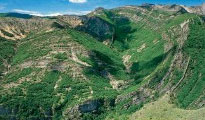
- Huanggang Dabieshan UNESCO Global Geopark
- Fangshan UNESCO Global Geopark
- English Riviera UNESCO Global Geopark
- Guangwushan-Nuoshuihe UNESCO Global Geopark
- Zhijingdong Cave UNESCO Global Geopark
- Dali-Cangshan UNESCO Global Geopark
- Xiangxi UNESCO Global Geopark
- Yuntaishan UNESCO Global Geopark
- Linxia UNESCO Global Geopark
- Kanbula UNESCO Global Geopark
- Wudalianchi UNESCO Global Geopark
- Changbaishan UNESCO Global Geopark

Huanggang Dabieshan UNESCO Global Geopark, with a core area of 2625.54 square kilometers, located in the south of Dabie Mountains, and to the northeast of Hubei Province, is situated at the north bank of the Yangtze River. It joined the GGN in 2018. As an important dividing line of geography, geology, climate and ecology of the Central Orogenic System in China, with the significance of global geological comparison, Huanggang Dabieshan UNESCO Global Geopark retains multiple phases of deformation ever since the Archean and various geoheritages resulting from magmation. Combined peaks, forest, pools and waterfalls with religious culture, folk custom and historic human heritages, there are ridges and peaks, sea clouds, vast forest, singing birds and sweet-scented flowers. Characterized by the continental orogenic belt structure and granite mountain landscape, Huanggang Dabieshan UNESCO Global Geopark boasts rich geosites, unique natural and culture heritage, which are rare, representative, integral, systematical and beautiful, is not only a natural laboratory of geoscientific research and research base for orogenic belt, but also a nature protected area with good ecological environment, profound culture great scientific value.